Explore the Historic Trail

The King's Highway Historical Trail is an interactive map and trail guide where you can explore Colonial and Revolutionary Philadelphia along America's first highway — Frankford Avenue. It grew out of the documentary "The King's Highway." The trail map lets you walk the same road and discover historic landmarks: churches, colonial inns, museums, and Revolutionary War sites.

On the Trail Map site you get an interactive map, category filters, and detail pages for each site — plus a printable PDF trail guide. It's a companion to the documentary, created so people can walk the road and discover the landmarks featured in the film.

What You Can Do on the Trail Map

Interactive Map

Explore the King's Highway corridor in Northeast Philadelphia with markers for historic sites.

Filter by Category

Filter by type of site — historic churches, inns, museums, military, cemeteries, and more.

Site Details

Tap markers for quick info (photo, summary, address) and open full pages for each landmark.

Printable Trail Guide

Download a printable PDF trail guide for walks and reference.

Map Styles

Switch map styles (modern, dark, satellite) for different views.

Free Map with Purchase

Purchase anything from our Shop and you'll automatically receive a free King's Highway Trail Map (shown below) with your order.

Start Exploring

Visit the interactive Trail Map to discover historic sites along the King's Highway.

King's Highway Trail Map — Free with any purchase

Get This Free Map with Any Purchase

Everyone who purchases anything from our Shop automatically receives this King's Highway Trail Map — free. No special code or add-on required.

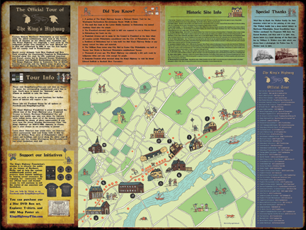
The map lists dozens of historic locations along the King's Highway for you to explore. Perfect for walking tours and reference.

Shop Now — Free Map Included

The King's Highway Historical Trail is a project of The King's Highway Trust Foundation.

Learn more in the documentary The King's Highway

Get a free map with any purchase from our Shop